How do you express the soulless husk of the corporate world in a game like Cyberpunk, without going over the top into parody? Tantacrul’s video on Corporate Music – How to Compose with no Soul, was just the inspiration I needed to create some soulless hell.
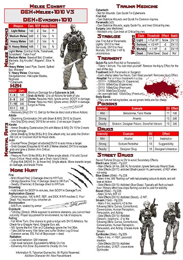
Cyberpunk Red Cheatsheets
Put together these cheatsheets for Cyberpunk red to make running the game easier


Cyber-helms for all situations
<corp jingle>
The Micro-Air bubble for all of your outdoor needs,
filters out neurotoxins floating around the streets.
</corp jingle>
Word from the street:
… Hey man these things are great, just hook them up to the auto-doc atomiser, and breath in your concoction of choice …
– Unknown ‘Dorpher
… Upgraded a batch of these for the 13th district PD, with armored faces, smart-google HUD, and rebreathers. Worked a charm, except if you smack the exhaust port, the facemask pops right off …
– Kutter, Techie
… Got to watch the effects when a Netrunner, flipped the filter direction and sucked all the air out … I’ll never use them again …
– Gimbals, Street Solo
An 18-month break?!?
From the midst of the storm of the last 3 years, I’ve had to pack a lot of side projects away while I focused on my job. So, a while ago I archived this website. Bring things back online it’s been 18 months since the last post.
Now, to pick up the pieces. Reorganise the parts into something coherent. Maybe a facelift. A continued imaginary exploration of the other worlds. Fantasy realms of the past, the all too near future of dystopian oligarchs, and an expanse of sci-fi stars stuck in an all too familiar pattern of human conflict.
A Map for Shadowrun
Playing in a game of Shadowrun 5e and the question of maps came up. in particular, Ley lines and connecting them to the game world. Luckily, the Internet contains geeks who have made something that could be used. the main challenge was getting the data that could be moved into Google Maps or Google Earth. Note: the upload limit for Google Maps kiboshed that idea
The Shadowrun world map was quickly solved, thanks to Reddit thread, Google Earth Shadowrun.
Although there are a lot of sites on Ley lines with helpful titles like;
- How To Find Ley Lines On Google Earth
- Google Earth Ley Lines Overlay
- Ley Lines Google Earth
- Earth Ley Lines Map Australia
- Ley Line Map Google Earth
None of them seams to have anything useful.
Leylines.net does have a Google Earth style map, but the data was hidden so it can not be combines with the Shadowrun map.
A bland-looking website… strangely enough these older websites tend to have the better data… had Explore the UVG Grid with Google Earth with a useful kmz file to upload to Google Earth.
The two together make a great resource for Shadowrun GMs and players
Cyberpunk Red Character sheet
My 2 page version of the Cyberpunk Red Character sheet.


Update: I had some problems with the fillable fields, but that should now be fixed. Thanks to those who pointed it out.
Drink the Future
Lockdown’s been driving most people crazy and I’ve needed a way to add to my campaign. So, I’ve been working on some background elements for my Near Future Campaign. It’s a Work in Progress at the moment, as some labels need changing.
NeuroPop!
Soda for your brain!
Loaded with neuro-chemicals to enhance your thinking.
AmphetaCola
For that edge in speed AmphetaCola is a cut above the rest.
SodaTranq
Reload that relaxed feeling, with SodaTranq.
Available in 2 flavours Grape & Berry.
The gorgeous grape relaxant cuts the edge off.
Drift off into berry bliss.
FADE Sheets
These are for the Fast And Dirty Expendables (FADE) in Cyberpunk Red.
Use for Whatever…
Blender Camera-Notes
Part of moving my projects over Blender 2.83 LTS is collecting my notes on various topics, including cameras.
5 cool camera tricks in Blender 2.80, this covers some cool stuff. However, I’ll have to manual set up the cameras until isocam gets updated.
Isometric Camera
From the Isocam script:
- The one, TrueIsocam called camera, is the mathematical correct isometric camera with the 54.736 rotation to get the 30 degrees angles at the sides of the rhombus. (54.736,0,45)
- The other, GameIsocam called camera, is a camera with which you can render isometric tiles for a 2d game. Here we need a 60 degrees angle instead of the 54.736 one to get a proper stairs effect and a ratio of 2:1 (60,0,45)
- Then there is the special case with a 4:3 ratio, which is button 3. You can also make 2D games with that one. The view is more topdown though as with a 2:1 ratio of the traditional game iso view. (41.5,0,45)
It’s worth noting that for TrueIsoCam, the X-Rotation Slot can be set to ( atan( sqrt(2) ) ) degrees.
Fantasy mapping
Ever since reading Tolkien as a kid, I’ve just loved the style of map that he created for Middle Earth. And this style has carried across to Fantasy RPGs. So when the opportunity came to create a map for The Tales of Tarya series, I jumped at it.
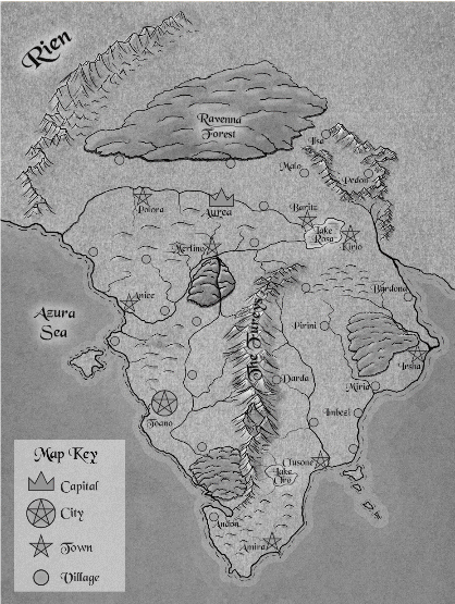
This time I wanted to make a good quality digital copy for this project. YouTube came to the rescue with this excellent video on mapping from the Fantastic Maps Channel.
Drawing Technique
A short summary of the technique for mountains…
- Use a CC-0 paper or parchment texture for the background layer (0).
- Add a separate ‘lines’ Layer (4) for the mountain ridge lines and some texturing detail. Use the pressure-sensitive to control the thickness of the line
- Add an Overlay layer (1), for the ‘Light & Shade’ on the mountain ranges. Use the pressure sensitivity to control the darkness.
- Start by blocking out the shading of the dark side of the mountain range. Take your time to build up layers of darkness.
- Add shadows to the light side for the ridges and valleys.
- As you go reduce size to add more detail.
- Another Overlay layer (2), for the ‘Light/Shade Detail’, but this time using the pressure sensitive to control line thickness.
- Then switch to a white brush to add highlights to the light side, with the peaks being the brightest.
- Now, a Color Layer (3), to add the colour details to the mountains.
- Using a hard round brush set to a middle grey for bare stone, deep emerald green for Amazonian forest, or red for the Arizona badlands.
Combine that into a group I then proceeded to do the same for the coastline, hills, forests, rivers, cities/towns, and labels. So about 20 layers all up.
You must be logged in to post a comment.